

Cape Town Regional Wall Map


Cape Town Regional Wall Map
Buying for a school, company or government department? Request a quote and order on invoice.
Wall Map · 7th edition · est. 1958
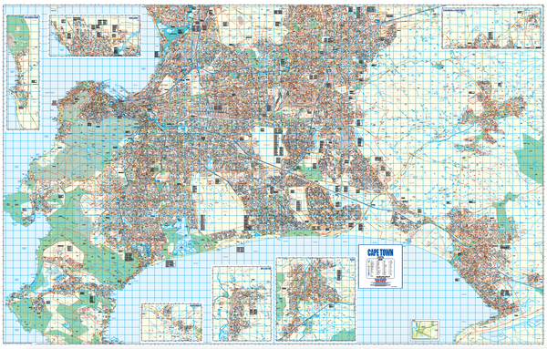
The Cape Town Regional Wall Map covers the Western Cape around Cape Town at 1:100 000, reaching across the Swartland, Drakenstein, Witzenberg, Breede Valley, Stellenbosch, Theewaterskloof and Overstrand municipalities — the Peninsula, the Cape Flats, the Winelands and the coast on a single sheet.
Roads are graded from freeways and national roads to through routes and minor roads, with route markers, tunnels and toll plazas. Railways and stations are shown, along with IRT main stations, airfields and the international airport — and hospitals carrying a casualty unit are distinguished from those without.
The sheet also carries provincial, municipal and suburb boundaries, retail, industrial and built-up areas, informal settlements, parks and sports grounds, spot heights, lighthouses and water features. Wine estates and wine sales outlets have their own symbols and are named individually.
Suitable for
Regional logistics and distribution. The graded road network, route markers, toll plazas and industrial areas cover the whole metro and out into the Winelands and West Coast on one sheet — built for routing across the region rather than within a suburb.
Emergency, health and response services. Hospitals and clinics with casualty units are distinguished from those without, across the full regional footprint.
Wine tourism and hospitality. Estates and wine sales outlets are individually named and symbolised, from the Constantia valley through to the Boland.
Municipal, planning and property work. Provincial, municipal and suburb boundaries are drawn, with retail, industrial, built-up and informal areas distinguished.
Not the right map if you need street names. At 1:100 000 this shows the road network rather than individual streets. For street-level detail, see the city wall maps.
Specification
- Scale
- 1:100 000
- Edition
- 7th
- Map Size
- 1380 × 1775 mm
- ISBN
- 9781770266124
Every sheet researched, compiled and updated in South Africa.
Buying this map
- Format
- Ready to Hang comes with a plastic batten fixed along the top and bottom, so a large sheet hangs flat and straight as soon as it is up. Laminated Sheet is the same laminated map without the battens.
- Delivery
- Delivery anywhere in South Africa is R250 for wall maps — one flat fee for the order, not per map, so a set of sheets costs the same to deliver as one. Orders are dispatched within 2 working days of payment; allow 3 to 5 working days for delivery.

Schools, companies and government
Order on invoice, or ask for a quote.
If your organisation needs a formal quotation or pays on invoice, skip the card checkout. Tell us the quantity and finish and we will send a quote within one working day.
- A formal quotation you can put through procurement, with our VAT and banking details.
- One quote for the lot — a set of provincial sheets, or one map for every classroom.
- Payment by EFT or purchase order. Your order number goes on the invoice.
Quotes are handled by Louise Lumb in Cape Town — +27 79 462 1260 if you would rather talk it through.
Quote for Cape Town Regional Wall Map · from R 4,450.00