

World Executive Wall Map (Small)


World Executive Wall Map (Small)
Buying for a school, company or government department? Request a quote and order on invoice.
Wall Map · est. 1958
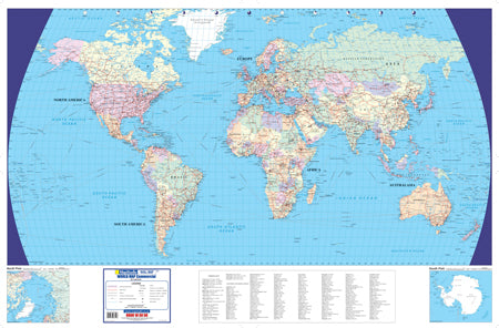
The World Executive Wall Map (Small) shows the whole world on the Van der Grinten projection at an equatorial scale of 1:40 000 000, on an A0 sheet.
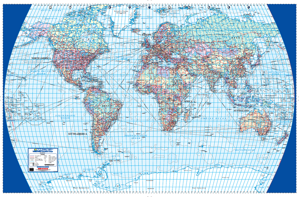
Because the Van der Grinten projection stretches distance away from the equator, the sheet carries a scale diagram rather than a single scale bar: the distance scale is read off the curve for the latitude you are working at, from the equator down to 75 degrees, in kilometres or in miles. It is an honest way to handle a world projection, and it is printed on the map rather than assumed.
Cities are graded by population — over five million, one to five million, 100 000 to a million, and under 100 000 — with national capitals distinguished from state and provincial capitals, and the capitals of small island states numbered into keyed panels where the map has no room to letter them in place. Territories administered by or belonging to another country are labelled with it. Boundaries are drawn at three levels — international, state, and disputed or undefined — and the International Date Line is shown. Shipping routes are drawn across the oceans, named port to port, with their distances in kilometres.
Suitable for
Trade, shipping and export planning. Ocean routes are named port to port with their distances in kilometres printed along them — Cape Town to Fremantle, Rio de Janeiro to Cape Town, Durban to Fremantle and the rest.
Offices and reception areas. A full political world map on a standard A0 sheet — the size that fits a normal office wall without rearranging the furniture.
Sales and account territories. State and provincial boundaries are drawn inside the larger countries, not just national outlines, and dependencies are labelled with the country that administers them.
Classrooms and training rooms. The projection is named and its distortion is shown as a diagram — the map teaches something about maps as well as about the world.
Not the right map if you need a larger sheet. For a world map at nearly twice the width, see the World Executive Large Wall Map.
Specification
- Scale
- 1:40 000 000 at the equator
- Map Size
- 1190 × 840 mm, A0
- ISBN
- 9781770269392
Every sheet researched, compiled and updated in South Africa.
Buying this map
- Format
- Ready to Hang comes with a plastic batten fixed along the top and bottom, so a large sheet hangs flat and straight as soon as it is up. Laminated Sheet is the same laminated map without the battens.
- Delivery
- Delivery anywhere in South Africa is R250 for wall maps — one flat fee for the order, not per map, so a set of sheets costs the same to deliver as one. Orders are dispatched within 2 working days of payment; allow 3 to 5 working days for delivery.
Schools, companies and government
Order on invoice, or ask for a quote.
If your organisation needs a formal quotation or pays on invoice, skip the card checkout. Tell us the quantity and finish and we will send a quote within one working day.
- A formal quotation you can put through procurement, with our VAT and banking details.
- One quote for the lot — a set of provincial sheets, or one map for every classroom.
- Payment by EFT or purchase order. Your order number goes on the invoice.
Quotes are handled by Louise Lumb in Cape Town — +27 79 462 1260 if you would rather talk it through.
Quote for World Executive Wall Map (Small) · from R 2,450.00